الاثنين، 4 يوليو 2011

وظائف شاغرة

لكل من يرغب في العمل في مجال السياحة  والبورصة والذهب براتب شهري كبير للتسجيل إضغط     هنــــــــــــــــــــــــــــــــــــــــــــــا   وسجل بياناتك ستحصل علي 250$ دولار فور التسجيل وبعد ذلك يتم إعتمادك للعمل.
لن تتطلع علي اي بيانات بخصوص العمل إلا بعد الدخول والتسجيل .
للتسجيل إضغط علي الصورة


معالم مصر السياحية في القاهرة و الفيوم و الأسكندرية و بورسعيد


جمهورية مصر العربية

تعتبر مصر واحدة من أبرز نقاط الجذب السياحي بين دول العالم نظرا لما تتمتع به من كنوز سياحية متعددة الوجوه، ومن أهمها السياحة الثقافية حيث الحضارات القديمة ماثلة للعين، وتنطق بما كانت عليه الأمم التي شيدت تلك الحضارات منذ فجر التاريخ.

والى جوار المنتج السياحي الثقافي القديم فإن تراكم عطاء تلك الحضارات اختزن في تراث انساني فريد تعبر عنه حياة المصريين المتنوعة والغنية بأنماط مميزة من الطبائع والسلوكيات والعادات جعلت من الانسان المصري نفسه، المجبول بعصارة موروثات حضارية عريقة، نقطة جذب سياحي منفرد.


ولم تبخل الطبيعة على مصر بعطائها فقد وهبها الله سبحانه وتعالى تميزا في طبيعتها يستهوي الأبصار والقلوب، ولا يكتفي الجمال والسحر بمجرد النيل وعاء أبديا يستقر فيه وإنما امتد جمال مصر ليزين ساحليها على البحرين الابيض والأحمر وليغوص عميقا في صعيدها وينتشر في صحرائها وليصنع ذلك كله العنوان الاشهر.. مصر عبقرية المكان، مصر غنية عن التعريف.. في التاريخ هي الأشهر.. فرعونيا، يونانيا، رومانيا، عربيا، اسلاميا، وفي العطاء الانساني، هي معمل ومخزن المنتوج الثقافي العربي والانساني، في الفكر والادب والسياسة، والفن، والصحافة والعمارة، لقد تفردت مصر بكثرة المناطق الجاذبة للسياحة ويترافق مع هذه المقومات الهائلة للمنتج السياحي المصري بنية اساسية متطورة وحديثة من المرافق والمنشآت ومختلف مستلزمات الخدمات السياحة الراقية من مجموعة كبيرة من افخم الفنادق العالمية الى شبكة مواصلات جوية وبرية وبحرية ونهرية متميزة والى مرافق اتصالات ومراكز ارشادات سياحية تجعل من زيارة السائح الى مصر مهما كان هدفه ومقصده زيارة مفعمة بالمتعة والاثارة والفائدة.

المعلومات الأساسية

العاصمة:
القاهرة

هي عاصمة جمهورية مصر العربية
أهم المدن: الاسكندرية، بورسعيد، السويس، الاسماعيلية، طنطا، دمياط، أسوان، الاقصر، أسيوط، الزقازيق، سوهاج، الفيوم، العريش، شرم الشيخ، مرسى مطروح، المنيا، المنوفية، بني سويف، مريوط، الغردقة، الدقهلية، المحلة.
المساحة: 997.738 كم مربع.
عدد السكان: حوالي 70.7 مليون نسمة (2002م)
اللغة الرسمية: اللغة العربية وتستخدم اللغتان الانجليزية والفرنسية في المعاملات التجارية.
اليوم الوطني: عيد الثورة في 23 يوليو (قامت عام 1952).
التوقيت: ساعتان + غرينتش.
العملة: الجنيه = 100 قرش = 1000 مليم
الكهرباء: 220 فولت.
الهاتف: الخط الدولي 02
العطلة الاسبوعية: الجمعة للدوائر الحكومية وفي القطاع الخاص الجمعة او الأحد.
الدوام الرسمي: من 8 صباحا الى (2)ظهرا،أما المصارف فمن 9 الى 1.30 ظهرا ومن 10 الى 12 يوم الأحد وعطلة المصارف يومي الجمعة والسبت.

التأشيرات:
الزامية لجميع الزائرين الاجانب باستثناء رعايا الدول العربية.
المرافئ والمطارات: مطار القاهرة على بعد 22.5 كم من وسط البلد ومطار الاسكندرية على بعد 8 كم من وسطها وهناك مطارات في كل من اسوان والأقصر، والغردقة، وشرم الشيخ وعدة مطارات اخرى. ويوجد المرفأ الرئيسي في الاسكندرية وتوجد مرافئ أخرى في بورسعيد والسويس ودمياط .
التقسيم الاداري: مصر مكونة من 26 محافظة بالاضافة الى مجلس مدينة الاقصر .. والمحافظات هي: الدقهلية، البحر الاحمر، البحيرة، الفيوم، الغربية، الاسكندرية، الاسماعيلية، الجيزة، المنوفية، المنيا، القاهرة، القليوبية، الوادي الجديد، الشرقية، السويس، اسوان، اسيوط، بني سويف، بورسعيد، دمياط، جنوب سيناء، كفر الشيخ، مطروح، قنا، شمال سيناء، سوهاج.
الموارد الطبيعية: البترول، الغاز الطبيعي، الفوسفات،خام الحديد، المنجنيز، القصدير، الزنك، الجبس، الاسبستوس.

المنــــــــاخ:

مناخ مصر معتدل بشكل إجمالي ويسود نصفها الشمالي تقريبا المناخ السائد في حوض البحر الابيض المتوسط المتغير تبعا للفصول الأربعة وفي الصحراء الغربية يسود الطقس الجاف فلا تزيد نسبة الرطوبة على عشرة بالمائة. ويكون حارا جافا صيفا وباردا ممطرا شتاء.

نبذة جغرافية

تقع مصر بين خطي العرض 22 و 31.5 شمال خط الاستواء وبين خطي الطول 25 و 37 شرقي غرينتش وهي تحتل الركن الشمالي الشرقي لقارة افريقيا وفي قلب العالم العربي بين جناحيه الآسيوي والافريقي وتحدها ليبيا من الغرب والسودان جنوبا، وفلسطين والبحر الابيض المتوسط من الشمال والبحر الاحمر من الشرق. وطبوغرافية مصر تتكون من أربعة اقسام: الاول الاراضي الزراعية ونهر النيل وهو أهم السمات الطبيعية لمصر، ويذكر هنا قول هيرودوت «مصر هبة النيل» وهو أطول أنهار العالم ويبلغ «6690» كيلومترا والدلتا تأخذ شكل مثلث رأسه في الجنوب حيث يتفرع النيل الى فرعيه: دمياط ورشيد شرقا وغربا حيث تتميز الدلتا بخصوبة تربتها. أما القسم الثاني فهو الصحراء الغربية الممتدة من وادي النيل والدلتا حتى الحدود الليبية في الغرب وحتى حدود السودان من الجنوب وتبلغ مساحتها 68 بالمائة من مساحة مصر. والثالث الصحراء الشرقية «شرقي النيل» حتى البحر الأحمر ومساحتها 22 % من مساحة مصر. أما القسم الرابع فهو شبه جزيرة سيناء وتبلغ مساحتها 6% من مساحة مصر.< قناة السويس

أهم الممرات البحرية في العالم وتربط البحرين الابيض والأحمر لتختصر الطريق التجارية القديمة حول رأس الرجاء الصالح طولها 184كيلومترا بدأ حفرها عام 1858 وافتتحت 1869 ومن أجلها خاضت مصر ثلاث حروب أعوام 1956 ، 1967 ، 1973

نبذة تاريخية

تاريخ مصر ماثل في المعالم الحضارية والأثرية التي مازالت قائمة وتروي فصول تاريخها منذ العهد الفرعوني الأول وفي مقتنيات المتاحف المصرية العديدة التي تسجل تفاصيل دقيقة عن حياة الأمم والشعوب التي عاشت في وادي النيل منذ نحو سبعة آلاف عام وحتى عصرنا هذا.
وربما يجوز القول ان تاريخ مصر يختلف عن تاريخ كثير من الدول التي تسجل تاريخها تبعا لتعاقب الأنظمة السياسية التي حكمتها، في ان تاريخ مصر تسجله حضارات تعاقبت وخلفت بعد زوالها تراثا استلمه الخلف ليضيف إليه.


وتاريخ مصر تتداخل فيه الرواية الآثارية والتأريخية مع الرواية الدينية. مابين قصة الأسر الفرعونية القديمة وما جاء في الكتب السماوية من قصص الانبياء الكرام الذين عبروا مصر وعاشوا فيها وعلاقات هؤلاء بأهلها القبط وصولا الى بداية التاريخ العربي الاسلامي الذي يعتبر التدشين الفعلي لمصر الحديثة عندما اتخذ الفاتح عمرو بن العاص من موقع القاهرة الفسطاط عاصمة لولايته.


لقد دونت الرواية الدينية تاريخ مصر ولكن باتجاه استلهام العبر والعظات وغرسها لقيم التوحيد والحق والعدل والدعوة لعبادة الله الواحد ومع بداية الحكم العربي الاسلامي بدأ تدوين تاريخ مصر يأخذ سمات التوثيق والترتيب والتفصيل تواترا عن الرواة وتسجيلا في الكتب الأولى.
< ولقد حظيت مصر بتاريخ موثق بالأدلة الحسية أكثر من أي بلد آخر فنقوش الفراعنة ولغتهم الهيروغليفية التي فك رموزها شامبيليون تتضافر مع كتب الرواة العرب والمسلمين ومع الرواية الدينية التي جاءت بها الكتب السماوية وصولا إلى تسجيلات الرواة والرحالة والمكتشفين والمستشرقين الغربيين. ومصر متحف لا تحده مساحة ولا زمان، فيه شواهد ومعالم تروي حضارات وقصص القبط والفراعنة والعائلة المقدسة واليونان والرومان والعرب المسلمين الذين استقروا منذ نحو 15 قرنا فيها وأقروا هويتها العربية الاسلامية بجذورها الحضارية المتعددة، وفيها آثار من بصمات الغزاة الذين طمعوا وعبروا ورحلوا من فرنسيين وانجليز وغيرهم. حضاريا يمكن الاقرار بأن دولة مصر الحديثة تأسست مع بداية عهد أسرة محمد علي الكبير الذي جاء من البانيا واليا عثمانيا فاتجه بولايته نحو الاستقلال وأرسى دعائم نهضة حديثة متطلعا إلى الحضارة الأوروبية الفتية وناقلا عنها نظمها وأساليبها ومظاهرها. وقد استمر حكم هذه الأسرة إلى أن تولى المصريون زمام بلدهم في 23 يوليو 1952 ليبدأ عهد الجمهورية المصرية بتولي الرئيس الراحل جمال عبدالناصر القيادة موجها دفتها نحو تأكيد لحمتها وهويتها العربية الاسلامية ودورها الريادي في المنطقة العربية حتى وقتنا الراهن. وخلال حكم أسرة محمد علي شهدت مصر موجتين استعماريتين قادمتين من أوروبا: الاولى هي الحملة الفرنسية التي قادها نابليون عام 1798 والتي تركت آثارا حضارية على المجتمع المصري، والثانية هي الاحتلال الانجليزي عام 1882والذي استمر حتى جلائه بعد ثورة يوليو عام 1952 . القاهرة

هي عاصمة جمهورية مصر العربية وأكبر مدن مصر وافريقيا وهي مقسمة الى ثلاث مناطق سياحية رئيسية: القاهرة الاسلامية التي تحتضن العديد من الآثار الاسلامية مثل المساجد والاسواق والقصور والأسوار،وفيها الجامع الازهر الشريف الذي شيد خلال الخلافة الفاطمية وأيضاً مئذنة بالاضافة الى المتاحف مثل متحف الفن الاسلامي الذي يقع في ميدان باب الخلق والذي يضم 80 ألف تحفة فنية تمثل الحضارة الاسلامية أشهرها اضخم مصحف في العالم مكتوب بخط اليد ومجموعة من الخزف الفاطمي ورسم للكعبة الشريفة على بلاط من الخزف إلى مجموعة من المباخر والشمعدانات، كما يوجد متحف قصر الجوهرة الذي شيده محمد علي وأيضاً متحف قصر المنيل الذي بناه الأمير محمد علي توفيق ويجمع طرازه بين العمارة التركية والعربية والفارسية ويضم مجموعة نادرة من المخطوطات والتحف الفنية للعصر العثماني . أما القاهرة الاخرى وهي المسيحية فتوجد بمنطقة مصر القديمة حيث توجد كنيسة المعلقة التي شيدت على البرج الجنوبي لحصن بابليون مقر الجيش الروماني بمصر القديمة، وقد شيدت على الطراز البازيلكي أيضاً كنيسة ابي سرجة التي استقرت فيها العائلة المقدسة بعد فرارها إلى مصر ولها ثلاثة هياكل وبهو يضم 12 عموداً مزينة بصور تلاميذ السيد المسيح وكنيسة العذراء عليهما السلام المعروفة بـ « قصرية الريحان» وكنيسة مار جرجس والتي بنيت في القرن الثالث عشر وكنيسة القديسة بربارة التي شيدت في أوائل العصر الاسلامي،وهناك مزارات مسيحية أخرى مثل شجرة العذراء الواقعة بالمطرية والمتحف القبطي الذي يحتوي على كتب نادرة تصل إلى سبعة آلاف كتاب عن الفن القبطي واللغة القبطية وتاريخ مصر خلال العصر القبطي. أما القسم الثالث من القاهرة السياحية فهو الفرعوني ويشمل مدينة اون الواقعة شمال القاهرة، ومدينة منف عاصمة مصر القديمة وأهم معالمها أهرام خوفو وخفرع ومنقرع، وأبو الهول،ومراكب الشمس وآثار سقارة وأهرم اوناس ومقابر النبلاء، ومنطقة آثار ميت رهينة وتمثال رمسيس الثاني ومعبد بتاح ومعبد تحنيط العجل الابيض وثالوث ممفيس من الجرانيت ومعبد رمسيس الثاني ومقصورة تي الاول ومنطقة آثار أبو صير ومنطقة آثار دهشور . وفي القاهرة يوجد المتحف المصري الذي يضم أكثر من 150 ألف قطعة أثرية معروضة ومئات الآلاف من القطع الموجودة في المخازن . ومن موجودات المتحف مجموعة آثار مقبرة توت عنخ أمون كما يضم تمثال الملك خفرع والملك منقرع وكنوز أميرات الاسرة الثانية عشرة، أما في منطقة الاهرامات فإن مشروع الصوت والضوء يحكي تاريخ مصر بعدة لغات خلال ساعة من الزمن تتخللها الموسيقى والمؤثرات الاخرى، وهناك عدد من المتاحف الاخرى في القاهرة . قايتباي والسلطان الغوري ومساجد عمرو بن العاص وابن طولون والسلطان حسن ومحمد علي . رمضان في القاهرة.. ســـياحــة من نـوع آخـــر إلى جانب سياحة الروح في الرحاب الايمانية التي تفتح آفاقها في شهر رمضان المبارك فإن لأيام الشهر الفضيل في القاهرة القديمة مذاقا خاصا قلما يوجد له مثيل في عواصم الشرق كلها.. وتتركز اوقات الاستمتاع بسياحة رمضان بين ساعتي الافطار والسحور في منطقتي ميدان الحسين وخان الخليلي فهناك في وسط القاهرة يمكن للصائم ان يتناول جرعة مكثفة من التاريخ وعظمته من خلال المباني التاريخية المحيطة. واذا رغبت بالمزيد فتوجه الى حي السيدة زينب لتشهد وتشعر بالاحتفال الحقيقي لشهر رمضان حيث زين السكان شوارعهم الضيقة بزينات ورقية ولكنها مبهجة، وتعلو الفوانيس غالبية شرفات المنازل ولا تخلو ناصية شارع او زقاق من باعة المخللات والخبز ومشروب العرقسوس وجميعها من بديهيات موائد رمضان. ومن المناطق التي تتحول في هذا الشهر الى ما يمكن ان يطلق عليه سياحة رمضانية منطقة القلعة وهي تعتبر بؤرة اي زيارة يقوم بها السائح الى القاهرة الاسلامية. وفي ميدان صلاح الدين، اسفل القلعة، الذي لا يخلو طوال العام من الأراجيح والخيام التي تستقبل رواد الموالد المختلفة يمكن للسائح الرمضاني ان يفوز باطلالة اخرى على رمضان الشعبي وذلك بارتياد المقهى المتاخم لمسجد السلطان حسن ومن هناك يحصل الرواد على متعة لا تقدر بثمن حيث يطل على مشهد مسجدي الرفاعي والسلطان حسن والمصلين والاطفال المحتفلين برمضان وباعة الحلويات الشرقية. ومع كوب الشاي «المنعنع» من مقعدك ستتيح لك الشاشات التليفزيونية العملاقة متابعة ابرز المسلسلات التي يدور معظمها حول صور من الحياة في مصر قبل ثلاثين او اربعين عاما او اكثر.. واذا كنت من محبي التميز فإن دار الاوبرا المصرية تقدم لك برنامجا حافلا بالاغاني والموسيقى ذات الطابع الرمضاني.. اما «محكي القلعة» فيقدم عروضا شيقة جدا ايام السبت والاثنين والاربعاء للموسيقى الصوفية. وينتهي يوم السياحة الرمضانية مع موعد السحور الذي تتكرر فيه مشاهد الموائد المتراصة والمشروبات المنعنعة ولا تتوقف الا مع اذان الفجر. الاسكندرية اهم معالمــــــــــــها مكتبة الاسكندرية
                                                 كوبرى ستانلى  العاصمة الثانية لمصر وأكبر موانئها على البحر الأبيض المتوسط بل هي أكبر وأهم موانئ الشمال الافريقي على المتوسط، وهي تضم كنوزا من المعالم الحضارية القديمة،وتتمتع بطبيعة نادرة وطقس معتدل طوال العام. ويمتد تاريخها لأكثر من خمسة آلاف سنة وفيها عشرات المزارات السياحية الحديثة والقديمة التي تضم المساجد والكنائس والقلاع والمتاحف والآثار الفرعونية واليونانية والاغريقية والاسلامية وفيها الاسواق القديمة والقصور الفخمة والحدائق الغناء، ومن عناوين حضارتها البارزة مكتبة الاسكندرية التي أعيد بناؤها حديثا لتكون صرحاً ثقافياً وحضارياً عالمياً، وشواطئ الاسكندرية خلابة مشهورة تعج بالمنشآت السياحية الجديدة والمنتجعات الاستجمامية والعلاجية والثقافية . وهي المدينة التي يجتمع فيها الماء العذب والماء المالح إذ يأتيها العذب من نهر النيل عن طريق ترعة المحمودية التي تخترق المدينة بطولها والماء المالح من المتوسط هذا ناهيك عما يلاقيه الزائر من بشاشة الوجوه وكرم الضيافة الاسكندرانية. تقع الاسكندرية فوق الزاوية الغربية للدلتا المصرية، خطط لبنائها الاسكندر المقدوني عندما غزا مصر عام 333 ق.م الا انه توفي قبل ان يراها، وظل تخطيط المدينة الاغريقي قائماً طوال العصر الروماني، وفي العصر الاسلامي الذي بدأ بفتح مصر على يد عمرو بن العاص سنة 642م أصبحت المدينة محطاً لكثير من العلماء والأئمة والأولياء الصالحين وكما هو «الاكروبوليس» في المعمار الاغريقي أصبح المسجد يتوسط المدينة وتنتهي إليه شوارعها. ويقول «ابن الحكم» صاحب أقدم نص تاريخي وصل الينا عن مساجد الاسكندرية: هي خمسة مساجد: مسجدالنبي موسى عليه السلام ومسجد سليمان عليه السلام ومسجد ذي القرنين او الخضر عليهما السلام، ثم مسجد الخضر او ذي القرنين التالي عند باب المدينة الشرقي اما الخامس فكان مسجد عمرو بن العاص . وتزخر الاسكندرية بالعديد من الكنائس، والكاتدرائيات المسيحية مثل «كاتدرائية الكرازة المرقسية» بمحطة الرمل، التي بناها القديس مرقص الانجيلي أحد تلامذة السيد المسيح،وبها قاعة تؤدي الى مدافن البطاركة الأقباط حتى القرن الحادي عشر الميلادي، و«كاتدرائية اليونانيين الأرثوذكس» بمنطقة الشرق الأوسط وافريقيا بالمنشية الصغرى و «كنيسة سان مارك» و«كاتدرائية الروم الكاثوليك» و«الكنيسة الانجيلية» بالعطارين « وكنيسة دبانة» بمحطة الرمل، و«كنيسة الأرمن الكاثوليك» و«كنيسة مار مرقص» و«دير مار مينا» العجائبي بالعامرية. 
أسواق المدينة اشتهرت الاسكندرية في العصور الاسلامية المختلفة بكثرة صناعاتها وجودتها، وأهمها صناعة النسيج والفخار والزجاج والصابون والسفن، وربما تُعد صناعة النسيج أهم ما اشتهرت به المدينة، ولذلك كان العرب يعتمدون هذه الشهرة في كسوة الكعبة المشرفة. من أشهر أسواق هذه المدينة العريقة التي تستهوي السائح «سوق العطارين» الذي كان يختص ببيع كافة أنواع العطارة والبقوليات والبذور والحبوب، ثم اتسع نشاطه ليشمل كافة السلع الأخرى من ملابس وأجهزة وأحذية وغيرها ، كما توجد أسواق قديمة ما زالت محتفظة بخصائصها مثل «سوق الخيط» الذي يختص ببيع كافة أنواع الخيوط، والزراير، والسست ، وجميع لوازم فنون التطريز، والحياكة وسوق «زنقة الستات» المختص بجميع لوازم النساء ، و سوق المغاربة.. وغيرها. مساجد وكنائس الاسكندرية الحالية من أهم السمات الحضارية الإسلامية في الاسكندرية، المدارس والمنشآت الدينية المنبثقة عن الأزهر الشريف ومئات المساجد الكبيرة، القديم منها والحديث،ولعل أشهر تلك المساجد هي التي تتركز في حي الجمرك الذي يعتبر الثقل الديني في المدينة ، حيث يبلغ عدد المساجد فيه حوالي 80 مسجداً: «مسجد سيدي أبي العباس المرسي» ويمتاز بمنارته الشاهقة الارتفاع وقبابه الأربع. و«مسجد الإمام البوصيري» الذي يُعد من تلاميذ ابو العباس الُمرسي، واشتهر بالشعر الصوفي في حب الله تعالى ومدح الرسول صلى الله عليه وسلم ومن قصائده «نهج البردة»، و«مسجد سيدي ياقوت العرش» وتقع جميعاً « بميدان المساجد» بحي الأنفوشي المطل على البحر المتوسط و« مسجد سيدي جابر الأنصاري» و«مسجد القائد ابراهيم» الواقع في منطقة « محطة الرمل» الذي بُني عام 1240م. قلعة قايتباي
تقع قلعة قايتباي التي أنشأها القائد المسلم السلطان «الناصر بن قلاوون» للدفاع عن المدينة، فوق جزيرة فاروس بحي الأنفوشي، وهي من القلاع المشهورة في العالم بما تمثله من مبان محصنة تحصيناً ذكياً وهندسياً رائعاً، وتقع في الطرف الشمالي لمدخل الميناء الشرقي في نفس موقع فنار الإسكندرية العظيم، وقد شيدت القلعة في القرن الخامس عشر. المكتبات والمتاحف الفنية تفتخر الاسكندرية دائماً بأنها أول مدينة في العالم احتوت على أكبر المكتبات العالمية من قديم الزمان، ولعلنا نذكر مكتبة الاسكندرية القديمة، التي أُحرقت ، او دمرت ومن مكتباتها«مكتبة البلدية» التي هي من أقدم المكتبات التي تحتوي على مخطوطات وكتب نادرة عن الفتح الاسلامي والعصور القديمة، ولعل أحدث مكتبة أُنشئت بالاسكندرية هي مكتبة الاسكندرية الجديدة البديلة عن المكتبة القديمة التي دمرت، وقد تحقق بإنشائها حلم مئات السنين فأصبح حقيقة وصرحاً شامخاً أمامنا اليوم « بمنطقة الشاطبي» أو «لسان السلسلة» تحديداً على شاطئ البحر المتوسط في الحي الملكي القديم المنتمي للحضارات المصرية واليونانية والرومانية والاسلامية . القصور والمتاحف الأثرية
تحتوي الإسكندرية على العديد من القصور الفخمة أشهرها وأهمها «قصر المنتزه» المطل على البحر الابيض المتوسط، الذي يتوسط مساحة 350 فداناً من أخصب الأراضي الزراعية المزروعة بأروع الأشجار، ومجموعة من أحواض الزهور والحدائق الغناء،فهي جنة الله في الأرض، ويجاور القصر قصر آخر يسمى «قصر السلاملك» كان مخصصاً لرجال حاشية الملك السابق،وقصر ثالث يسمى «قصر الحرملك» خاص بنساء الحاشية، وتم بناؤها جميعاً على الطراز الاسلامي،كما ان هناك قصوراً أخرى مثل قصر «انطونيادس» بحدائق النزهة، الذي يقع ايضاً وسط حدائق خلابة تنتشر حوله تماثيل أبدعها عظماء الفنانين العالميين، و«قصر الصفا» بحي زيزينيا، و «قصر العروبة» و«قصر رأس التين» في منطقة رأس التين أو بحري، كذلك قصر الأمير كمال بمنطقة استانلي، وغيرها. المنشآت السياحية والترفيهية تشغل الاسكندرية شريطاً ساحلياً يصل الى 70 كلم على البحر، وهي تمتلئ بالعديد من المنشآت السياحية والترفيهية ، كدور السينما والملاهي والنوادي والمسارح وغيرها، ويتم تجميل كورنيش المدينة وتوسيعه بضعف مساحته، وأُنشئ العديد من الأماكن الترفيهية والسياحية بالقرب منه وبشكل لا يحجب التمتع بالرؤية الطبيعية لجمال البحر وشواطئه التي تمتد من أبي قير الى نهاية الساحل الشمالي قرب مدينة القاهرة،حيث تمتد القرى السياحية المصممة على أحدث الطرز السياحية العالمية على طول الساحل . وفي الاسكندرية عشرات الألوف من الشقق السكنية المفروشة المنتشرة في جميع أحياء المدينة، بالإضافة الى عشرات الفنادق، سواء من الدرجة الاولى ، أو من الدرجة الأقل والمنتشرة ايضاً على طول الساحل وداخل المدينة . وفيها أيضاً أنواع المطاعم والمزارات والمتنزهات العامة والخاصة والغابات الكثيفة بأطراف المدينة ذات الأشجار اليانعة والمثمرة، وتزدان شوارعها بالتماثيل والاعمدة الرخامية الضخمة . 
الــفـــــيــــوم
تقع مدينة الفيوم في قلب مصر بين الدلتا والصعيد جنوب غرب القاهرة بمسافة 100 كم وهي احدى الواحات في الصحراء الغربية وتعتبر صورة مصغرة لمصر حيث يمثل بحر يوسف نيلها ودلتاها وتمثل بحيرة قارون شمالها الساحلي. والفيوم تتجمع فيها كل عناصر الجذب السياحي وتمتاز بطقسها المعتدل طوال العام. وقد ظهرت فيها حضارات مصر المتعاقبة وتركت بصماتها من خلال الآثار الفرعونية واليونانية والرومانية والقبطية والاسلامية. وتبلغ مساحة محافظة الفيوم (6068.70كم2) وهي تضم خمسة مراكز ادارية هي (الفيوم، سنورس، إطسا، طامية، ابشواي). وقد التقت بيئات الفيوم بانواعها الثلاث - الساحلية والريفية والصحراوية - معا في تناغم جميل لا يتوفر الا لها. ومن ابرز معالم البيئة الساحلية التي تشكل عنصر جذب اساسي للسياحة بحيرة قارون التي تبعد 20 كم عن المدينة و 80كم عن القاهرة ويتاح فيها ممارسة الرياضات المائية وصيد الاسماك ومراقبة الطيور المهاجرة والمقيمة وتقع على ساحلها الجنوبي مجموعة من المنشآت والقرى السياحية. سياحة البيئة الصحراوية: الفيوم قريبة الشبه بالواحة، حيث تحوطها الصحراء من كل جانب عدا نقطة اتصالها بالنيل. لذا فإن الصحراء تمثل 62% من مساحتها وهي غنية بنباتاتها وتكويناتها الجيولوجية وجبالها وتلالها وصحرائها وأوديتها وعيونها الطبيعية وطيورها وحيواناتها البرية النادرة، وقد اعلنت الصحراء الواقعة شمال بحيرة قارون وحول بحيرات وادي الريان محميات طبيعية نظرا لاحتوائها على مكونات بيئية وطبيعية نادرة. 
وتتيح سياحة الصحراء في الفيوم سياحة السفاري والسياحة الرياضية والسياحة العلاجية والسياحة البيئية والسياحة الثقافية زيارة مواقع الحفريات القديمة لآثار ماقبل الإنسان وقبل التاريخ والآثار الفرعونية واليونانية والرومانية بالمنطقة. 
حديقة الحيوان: وتضم مجموعة من الحيوانات المختلفة التي تجذب الزائرين ومقرها منطقة دله بالفيوم، ولأن الفيوم تحيطها الصحراء من كل جانب لذلك فإنها غنية بمكوناتها النباتية والحيوانية التي تعيش في الصحراء وخاصة الغزال الأبيض النادر. سياحة البيئة الريفية: اشتهرت الفيوم بأنها الصحراء وأنها سويسرا الشرق، وأنها الجنة الوارفة الظلال، حيث تبلغ المساحة المزروعة في الفيوم 26% من مساحة الفيوم، ويصل عدد العاملين بالزراعة فيها الى 67% من عدد السكان وتجود فيها أنواع من المحاصيل والفواكه الشهيرة، كما تشتهر بالطبيعة الرائعة والهدوء المحبب والصناعات البيئية المتميزة والفلكلور الأصيل.. وكان لتدرج أراضي الفيوم ووقوعها تحت مستوى سطح البحر أثره الكبير في ظهور الهدارات على مجرى بحر يوسف، فكانت ذات منظر أخاذ للسياحة وذات فائدة للزراعة عندما تدور عليها السواقي والطواحين. بـور سـعـيـد
أنشئت عام 1860 كميناء جديد على البحر المتوسط لقناة السويس ازدادت شهراتها عالميا بعد أن أصبحت مدينة حرة وتقع على بعد 220 كم من القاهرة و 80 كم من الإسماعيلية و 160 كم من السويس. تمتاز بشواطئها الجميلة الهادئة والرمال الناعمة وانعدام الصخور بمياهها كما تتمتع بموقع جغرافي يربط افريقيا بآسيا حيث تقع ضاحية بورفؤاد في قارة آسيا على البحر الشرقي لقناة السويس. يمكن القيام برحلة الى منطقة الجميل وهي على مسافة 12 كم غربي بورسعيد حيث تمارس هواية صيد الأسماك وكذلك يمكن القيام بنزهة بحرية في ميناء بورسعيد لمشاهدة قوافل السفن التي تعبر قناة السويس. متحف بور سعيد يضم حوالي 90000 قطعة أثرية ترجع لعدة عصور هي: الفرعوني، اليوناني، الروماني، القبطي، الإسلامي، العصر الحديث. متحف بورسعيد الحربى يضم لوحات مجسمة عن معركة 1956 كما يضم بعض القطع الحربية والأدوات العسكرية لحروب 1956 - 1967 - 1973 . شاطئ لسان عبدالرحمن والكاتدرائية مناطق صيد السمك للهواة، كوبري الجميل، حجر سعيد، التفريعة، كوبرى الخدمات ببور فؤاد. جزيرة نيس تبعد حوالي 9 كم ويمكن الوصول اليها باللنشات من محطة بور سعيد البحرية.  الموضوع الأصلي :- هنــــــــــــــــــــــــــــا

السبت، 2 يوليو 2011

نتائج الدبلومات الفنية 2011 في ثواني بدون روابط وهمية

نتائج الدبلومات الفنية 2011 في ثواني بدون روابط وهمية
نتيجة الديلومات الفنية 2011
لمعرفة نتيجة الدبلوم الصناعي والدبلوم الزراعي والدبلوم التجاري لعام 2011 من فضلك إضغط هنـــــــــــــــــــــــا وأدخل رقم جلوسك واختار التخصص في الدبلوم.
ولأصحاب النت الضعيف احصل علي نتيجتك في ثواني فقط اترك لنا رقم جلوسك ونوع الدبلوم وأحصل عليها علي الفور من موقعنا.
ونتمني للجميع التوفيق وألف مبروك لكل الناجحين.

الثلاثاء، 28 يونيو 2011

كليتنا وشعبة إدارة الأعمال: هل تري أن الأستاذ فريد الديب مقنع في دفاعه عن الرئ...

Egypt's tourist landmarks: Restaurants

Egypt's tourist landmarks: Restaurants: "المطاعم بمحافظة بني سويف


المطعم:
مطعم قصر البكرى
العنوان:
ش عبد الرحمن شاكر
التليفون:
..."

Egypt's tourist landmarks: Hotel Reservation

Egypt's tourist landmarks: Hotel Reservation: "الفنادق بمحافظة بني سويف
فندق سميراميس السياحي
العنوان: ش صفية زغلول التليفون: 0822322092
فندق قصر البكري
العنوا..."

Egypt's tourist landmarks: Hotel Reservation

Egypt's tourist landmarks: Hotel Reservation: "الفنادق بمحافظة بني سويف
فندق سميراميس السياحي
العنوان: ش صفية زغلول التليفون: 0822322092
فندق قصر البكري
العنوا..."

Egypt's tourist landmarks: Beni Suef

Egypt's tourist landmarks: Beni Suef: "Beni Suef Beni Suef is a province of Egypt. Its capital city of Beni Suef. Is within the province of Beni Suef Regional Planning at th..."

Beni Suef


Beni Suef
 Beni Suef is a province of Egypt. Its capital city of Beni Suef.Is within the province of Beni Suef Regional Planning at the North bounded to the north and south of Giza governorate of Minya and east provinces of the Red Sea and Suez and west of Fayoum governorate, with a total area of ​​conservation (7169 km 2).A census estimated population in January 96 (18601809 people) resides in the rural sector of the province (1422340 inhabitants)By up to 75% and the rate of population growth 2.69% per year to maintain.
When Egypt was divided to 42 provinces, the province of Beni Suef occupy parts of both regions and twenty-second and twenty provinces of Upper Egypt and the current conservative Medm land located in the Ptolemaic period within Ahnasia.Qaaw.jpg
The Beni Suef museum historically all ages, including many of the treasures of Egypt, which has the second oldest pyramid in the world, which was built by "King Hony" the last king of the Third Dynasty, and completed a constructive son of King Senefru the first king of the Fourth Dynasty, the father of King Cheops, builder of the Great Pyramid of Giza - also vary the pharaohs in villages (Abu Sir - Ahnasia - Funk Sdment mountain - Dchach - Alehibh - deceiver). And distributed throughout the province effects of Coptic churches and monasteries, including the monastery Alonpapoula and the monastery of St. Anthony in the center of Nasser and Church of the Blessed Virgin in the village of White Arab east of the Nile, Deir Mari Girgis Bsdment the mountain and have been found in the deceiver, a small village in the bosom of the mountain east on the east bank of the River Nile towards the town of Beni Suef on the small tomb of the mummy of a little girl was found under her head manuscript full line Coptic on the skin of a deer, it became clear from his translation that the Psalms of David is preserved the Coptic Museum now; and spread of Islamic monuments in the province where the tomb of Prince Ahmed very village sixth princes and Cemetery Marwan bin Muhammad in the village of Abu Sir is done by a mosque Ms. fairy in the town of Beni Suef on the 18 km and a cave Snoroho cave huge in the heart of the mountain a depth of about 17 meters distributed stalagmites and stalactites of alabaster pure in the form of spectacular in the ground cave in the eastern corner of it there is a Hungarian water drops the level of the cave floor is believed to be a means of water drainage accumulated in the cave.There are to maintain the University of Beni Suef, a public university has a number (12) College and was a college affiliated to the University of Cairo until the separation university independent in 2005 and the Faculty of Islamic Studies tracking Al-Azhar University Station for Agricultural Research and (7) vocational training centers, and the number of chapters of the pre-university education (12 264) the separation of public education exist, including the rural sector (6107) separated by 66.5% and (666) the separation of education Azhar We have them in the rural sector (390) separated by 53% of the seasons.The total cultivated area (264,451 acres) and excel in maintaining the productivity of wheat and cotton is also characterized by the productivity of onion and garlic and melons as well as medicinal and aromatic plants as a total area of ​​land suitable for reclamation to about (51,921 acres).


The most important investment activities in the agriculture sector

    
* Fish the field of investment.
    
* Crop production.
    
* Field of animal production and poultry.
    
* The production of honey.
    
* The area of ​​reclamation and cultivation of land.Contributes to the industrial activity through the production of cement and brick clay and weaving again behave like a big, carpets and kilims hand again behave like a junior. There are various activities of the agriculture sector and according to their comparative advantages of maintaining high It is noted that the agriculture sector still needs to be many of these activities to address population growth and meeting the needs of the citizen Elsweefe. There are many maintain research centers that provide technical services and guidance.The most important industrial areas

    
* Area of ​​light industry within the cordon area of ​​Beni Suef new 950-acre plot of 139 member-date facilities were fully booked and even started some plants in production.
    
* Medium industries within the cordon New Beni Suef.
    
* Small industrial complex area of ​​36 acres on the eastern Nile accommodate 300 and workshop.
    
* Blank area of ​​the Arab area of ​​750 acres.
    
* Mount the light area of ​​500 acres.
    
* Kom Abu Radi, with 655 acres.
In addition to an area of ​​heavy industries being established in the desert Wasti by the General Authority for Investment and Free Zones.Available investment opportunities in the industrial field
1 - the establishment of projects, spinning, weaving, tailoring, embroidery textiles.
2 - set up projects, yarn and fabric of carpets and kilims.
3 - manufacturer of garments, cotton garments of the Interior.
4 - the production of cotton wool and the fabric pile.
5 - manufacturing machinery agricultural machinery.
6 - manufacture of pumps, irrigation and greenhouses.
7 - establish manufacturing and packaging.
8 - set up paper industries.
9 - the establishment of industries of all kinds of wood (Furniture - The Furniture).
10 - Chemical Industries Kalmnzvat and cosmetics.
11 - production of concrete and brick and clay industries pottery and ceramics.
12 - manufacture of computers and recorders, television and air conditioning.
13 - the establishment of industries and modern electronic micro Aldoaúralamtnahih and accessories.
14 - the establishment of industries of plastic materials.
15 - output voltage electric transformers.
16 - production of electrical appliances and switches.
17 - Production wire telephone and television, and dishes.
18 - production overhead cranes.
19 - production of pumps, vertical submersible.
20 - production of scissors and Tnaat sheets.
21 - production of aluminum castings.
22 - Manufacture barges.
23 - production of machine guns pesticides.
24 - production of metal toys.
25 - production of diamond blades and the number of private publishing marble.Tourism Investment


Elements of the tourism investment:
1 - cultural elements: Beni Suef is in all phases of Egyptian history. It was essential to the region an important role in the era of the Ninth and Tenth Dynasties Bahnasaa the city, where was the capital of Musronmak. There are many archeological sites and ancient Egyptian and spread in all the centers of the province.
2 - natural landmarks in the form of: Nehralnal, Wadi Rayan, Senor protected cave, desert environment.
3 - the ingredients in the form of entertainment: an oasis Meidum, Beni Suef, gardens, zoo, entertainment district town of Beni Suef new.
4 - Almtnmthelh services in hotels, guest houses and banks.The Beni Suef museum great for all ages include many of the treasures of Egypt, where - has the second oldest pyramid in the world, which was built by "King Hony" the last king of the Third Dynasty, and completed a constructive son "King Bent," the first king of the Fourth Dynasty, the father of King Cheops, builder of the pyramid the largest in Giza.
- As are the Ancient Egyptian monuments in centers and villages (Abu Sir Ahnasia - Funk Sdment mountain - Dchach - Alehibh - deceiver). - Distributed throughout the province effects of Coptic churches and monasteries, including the monastery Alonpapoula and the monastery of St. Anthony in the center of Nasser and Church of the Blessed Virgin in the village of White Arab east of the Nile and Deir Mari Girgis Bsdment the mountain and have been found in the deceiver, a small village in the bosom of the mountain east on the east bank of the River Nile to the city Beni Suef on the small tomb of the mummy of a little girl was found under her head the entire manuscript of the Coptic script on the skin of a deer, a clear translation of the Psalms of David that is preserved is the Coptic Museum.
- Spread of Islamic monuments in the province where the tomb of Prince Ahmed very village sixth princes and the tomb of Marwan bin Muhammad in the village of Abu Sir is done by a mosque Ms. fairy in the town of Beni Suef, 18 km, a cavern huge in the heart of the mountain a depth of about 17 meters distributed stalagmites and stalactites of alabaster pure in the form of a spectacular cave in the ground in the eastern corner of it there is a stream falls below the level of the cave floor is believed to be a means of water drainage accumulated in the cave.The most important archaeological sites

    
* Abu Sir is done by
    
* Alehibh
    
* Dchach
    
* Heracleopolitan
    
* Sdment mountain
    
* MeidumMaintenance consists of 8 administrative centers 0.7 cities, 38 units village 0.225 a village. The centers of the province is:

    
* Beni Suef
    
* Nasser (Aelchenawih)
    
* Fashn
    
* BPA
    
* Heracleopolitan
    
* Wasta
    
* Samasta
    
* New Beni SuefMonths, the province
    
* Imam Sultan Busayri Almadhan impermeable and the owner of praise.
    
* Imam Alboiti the Imam Shafi'i.
    
* Imam Shihab al-Din Noueiri
    
* Reader Alvhny Sheikh Taha (center of the al).
    
* Imam Dr. Ali Gomaa, Grand Mufti of Egypt.
    
* St. Anthony
    
* Jehan Sadat, widow of the late Egyptian President Anwar Sadat
    
* Artist Hassan Abdin
    
* Information is useful Fawzi
    
* Director Amr Abdeen
    
* Artist (Nabil Mohammed Saleh Ahmed)Sons of the most famous stadium, Nabil Saleh Ahmed Al-Azhar district stadium of the most famous people of the province is also family-Salhi, which resulted in Sheikh / Hamza al-Salhi (may Allah have mercy on him) ... Mr. Al-Azhar University Prof. Dr. / Mahmoud Sami Abdalgod ... Professor of Psychiatry and Dean of the Faculty of Medicine palace kind previously Professor Dr / Zeinab Jawad (God rest her soul) ... Bmahadalawram professor of oncology professor Dr. / Tarek Mahmoud Sami Abdel Gawad ... Professor of Psychiatry and Chairman, Department of Psychiatry Aini Palace large media professor / Salhi attic .... Press and Journal newspaper of the Republic and Mahbubta my faith and the last hour the great Mr. Media / Abdel Halim Mohamed (may Allah have mercy on him), a columnist at El Republic, the great economist Prof. / Yahya Salhi ... First Undersecretary of the Ministry of Economy and the first candidate for Prime Minister Prof. Dr. / Hazem Abdel-Latif ... Professor of Engineering and Dean of the Faculty of Engineering, Ain Shams University Counselor / Sayed Zaki Moussa ... The State Council, Alhaji Mustafa Abdul-located ... Aware of the flags of the city and the village built the al-Saleh and there are a lot of the people of the province who would Ya'alon incapacitated or whenever they started

الجمعة، 17 يونيو 2011

Egypt's tourist landmarks: Books on Egypt

Fayoum Governorate


Site

Located in the heart of the city of Fayoum, Egypt between the Nile Delta and Upper South-west of Cairo distance of one hundred kilometers and is one of the oases in the Republic and is a microcosm of the Sea, Egypt, where Joseph is gaining and delta and represents the northern coastal Lake Karun .. The Fayoum of the most important tourist areas in Egypt, where they accumulate in which all elements of the tourist attractions which is characterized by the beauty of nature and its mild weather all year, has appeared in civilizations of pre-history, which left their mark immortal through the Pharaonic, Greek, Roman, Coptic, Islamic and an area of
​​6068.70 square kilometers and consists of six stations management is (Fayoum - Sonoras - Etsa - Tamia - Ebshiway - Prophet Yusuf).


Space

Fayoum Governorate is located in Western Sahara in the south west of Cairo and at a distance of 90 km and is one of the provinces of the North level which is surrounded by desert on all sides except the south-east, where related to the governorate of Beni Suef .. The total area has 6068.70 square km.

Geology

Fayoum is one of the provinces north of level 00 and related to Beni Suef to the south-east, 45 km, and bordered to the north of Giza at a distance of 85 km and is considered a low-Fayoum A reducers Egypt's main which is a cavity recessed in configurations Miocene, which will disappear under the geological formations latest relates to the low Nile through the slot Agon where intervention canal Bahr Yusuf A branch canal Ibrahimeya of the Nile at Dayrout to Fayoum to be the only source which supplies the Fayoum water (9.1 billion m 3) to tend to the decline in the level of +26 m at Agon to the level - 42 m the coast of Lake Karun
Is different from the rest of low-Fayoum Reducers in the population that Amer and he tells the Nile water and silt from the fertile soil which is transferred to low with the Nile water
It also brought together all of the properties, making the geographers call it: Egypt Minor
Is low only in Egypt, which includes agricultural and natural environments as the desert has a natural salt water lake and ancient and artificial lakes and tortured his

Terrain

Fayoum descended low from south to north in 3 main halls are:
Listed first: Agon from Aqueduct to the city of Fayoum (5.22 m)
Second runway: the city of Fayoum to the village of Sanhour (-10 m)
Third runway: Saint Catherine of Sanhour even to the shores of Lake Karun (-43 m)

Climate

Enjoy the province of Fayoum climate is hot and dry rare rain winter with sunshine To the world, reaching temperatures between 1.28 and 29 in July - In winter, temperatures range from the Great between 11 and 17 and a low of 4 and 10 degrees in January, and average annual rainfall is about 17 mm - which indicates that the Fayoum few rainy winters, dry summers
Have affected large bodies of water and the low level of the surface in some areas to below zero in the climate of much of Fayoum to the point of excellence than others, even if she shared the same degree of supply
Tourist areas in Fayoum Governorate
First natural reserves in the Fayoum
Wadi Rayan


Located in the southwestern part of the province of Fayoum, comprises the Wadi El Rayan from the lake, upper, and the lake bottom, and the waterfalls, which connects the lakes, and the eyes of Al Rayyan south of the lake bottom, and the Jebel Al Rayan, a region surrounding the eye, and the Mount retained, which is located near the lake bottom.

And is characterized by its own environment and the Wadi El Rayan, including integrated desert of sand dunes and the eyes of normal and various plant life and animals, as well as a variety of marine fossils, as are the waterfalls of various sea sports


There are reserve, 15 species of wild animals the most important (white deer - Egyptian deer - Fennec Fox - Fox
Sand - the wolf) and there are also several kinds of hawks.


Lake Karun

Lake Karun in the northwestern part of the province of Fayoum and is one of the oldest natural lakes in the world, a remnant of ancient Lake Morris, and is characterized by the presence of protected geological formations are important scientifically and historically, and by groups of plant variety


And are flocking to a lot of migratory birds and resident, has been the discovery of fossil mammals park dating back to about 10 million years ago, also appeared in fossils the oldest monkey in the world and some trees are fossilized, and there are some archeological sites in ancient Egyptian, Romanian, Coptic (such as the church - the Temple of goldsmiths - Temple Palace Karun -) as well as having some of the plant and animal fossils.


Wadi whales

Is the valley of whales within the protected area of
​​Wadi Rayan, which covers an area of ​​1759 km in Fayoum, 150 kilometers from Cairo, Egypt, and in the year 2005 was rated the Valley of the Whales as a World Heritage named by UNESCO as the best World Heritage areas of the skeletons of whales.
Valley is famous for whale sharks the existence of a full excavation was filled with the region 40 million years ago when the valley was located under the ocean a huge addition to the many marine fossils can be seen in the museum open to visitors, which allows the possibility of seeing whales and not compromising them for protection.

Discovered

The discovery of fossils and the Valley of the Whales in 1903 by the world, however, Hill through biological survey in Egypt has found fossils of whale known as Albasplosors Isis, which reaches a length of 18 meters and the whale Alldoryoron Atrox a slimmer has been defined as types of new whale in the Natural History Museum in London in 1902.

In 1989, discovered the team consisting of archaeologists and Egyptian Alomrikiyan first Aenja water to the structure of the whale Albasalosoros and Alldorjordn Otrox Bergelha and feet small, and in 1996 was the discovery of a whale another is a length of 5 meters is the whale Achirnos Simmons In 2006 the discovery of the first fossils of marine mammals one of the ancestors of the elephant known as Berathirm In 2007 was named the whale with a length of 10 meters as Masua Setse Markjrev, has the mission team mapping more than 400 whales and seals in the valley

Scholars have stressed that the valley of the whales is an exceptional site for the study of ancient life because of the large number of fossils of high quality up to more than 400 fossils of the skeletons of whales, were also found fossils for a bride to the sea and sharks and marine life again, and depicting the activity of these organisms that lived more than 400 million years old and way of life and land animals transferred from animals to freely and the region is the most numerous and focused and the quality of the fossil compared to other sites. As well as its presence in the logic of the protected attraction and is of great importance as world heritage.

Is also the Valley of the Whales natural environment of animals threatened with extinction, such as deer and white Egyptian deer, fox funk and Fox sand and the wolf, migratory birds, rare, such as Falcon and Saqr al-Ghazal and Falcon free and punishment Alencary and other types of migratory birds such as annua p ducks, quail and Altflq and annua p herons and the goats and others. And wild plants such as: Aqool - zygoghyllum - Acol - rush - the jungle - reeds - Algrdq - Halfa, and other

Breaks in the Valley Alehitanokd was a prelude to the Medkat and a dirt road length of 38 km and the demarcation of the roads leading to the valley and secured and the number of signs and the provision of toilets and a cafeteria offering products reflect the valley, visitors can acquired have been used materials place such as clay, silt and ropes Till date palm in the making of signboards and outline ways within the valley and on the location of structures whales. As has been the work of the structure of a small whale shark Albasilosors and teeth, and the preparation of a museum open to display the whales in an excellent way to allow visitors to see and not compromised in the same.


The most important archaeological monuments and shrines Pharaonic Fayoum
The effects of pre-dynastic era

Gerzh area was found by the cemetery is the last phase of pre-dynastic period.
The effects of age of first and second families

Tarkhan is considered one of the effects of first and second families, where they were found on the cemetery of the two families I and II, and a large terrace from the era of the first family has a facade of brick, and a small cemetery of the First Dynasty.
The effects of the era of the Third Dynasty
Sila and the pyramid is located on the eastern edge of the Fayoum facing low to rupees village east of Fayoum was not fully disclosed, which is different in design from the traditional pyramid is based on high and has a runway, due to the Third Dynasty.


The effects of the Middle Kingdom
Temple of the palace chapel, is located 8 km north of Lake Karun, a building of limestone and sandstone and contains the palace of seven compartments, and an area of ​​about 180 meters, is located in the south of the cemetery of the Middle Kingdom.

The Cayman Persia (Orsenauy) (constructed) is out of the city of Fayoum old and was founded in the era of the Fifth Dynasty, and flourished in the era of the family of 12 was established by King Amenemhat the Third Temple of God, casting and named it (built) and then called (Orsenauy) in honor of his wife, and located within the city Fayoum district, university and was an area of
​​220 acres of this is the ruins of the widest known from the remains of Egyptian cities, is located to the north of the city's main synagogue of the Middle Kingdom, as found by the Alyathar includes a statue of Amnhat third of black granite, and the papyri, and bronze coins, and Clay Figurine .. The Antiquities Authority has an inventory of what now remains of these effects and enclosed by fencing.

Obelisk of Senusret


An existing 13 m high granite top and round the hole to install a crown or a statue of King .. Set up by King Senusret I of the kings of the family of 12 to commemorate the start of conversion of agricultural land to the Fayoum has been moved from its originallocation in the village of Fayoum Abjeej to the entrance of the city of  Fayoum in 1972. 
Pyramid of Hawara
Located in the village of Hawara on the 9 km southeast of the city of Fayoum and built this pyramid of brick and encased in from abroad, with limestone and with a rising 58 meters and the length of each side 100 meters have been succeeded Petrie in 1889 to enter the pyramid and get to the burial chamber, which consists of the mass of one huge Alkuartset of stone and weighing up to 110 tons and has no door but the thieves were able to access it through a hole in the roof and stole the most important Mavera was built the pyramid of King Amenemhat III of Dynasty 12 .. The area includes the surrounding pyramid set of effects, including a cemetery and the remains of Princess Nfruptah Palace Allabernt and cemeteries of the Late Period, which was found on the Fayum portraits.


Ruins of the city's past


Located about 35 km southwest of the city of Fayoum near Manor reagent South Sea girls and includes the ruins of the temple from the age of the family of 12 was built by King Amnhamat the third and fourth, then added to Firefox in the Roman era, where it was put by the statues of black with severed heads, and is the largest temple of the rest of the Middle Kingdom in Egypt .. And can be accessed from the Fayum to Abu Jendar Sea and then to the girls and then to the temple.

Palace Allabernt
Is the temple of Amenemhat III, and no region of Hawara, was built adjacent to the Pyramid of Hawara and was a 12-lobby lounge are all covered, six of which are heading north and six heading south and have gates correspond to each other completely, and takes the whole building one wall and there was the building are two types of rooms half underground and half on the surface of the earth, and the estimated number of such rooms with 300 rooms, closets and the lower the tomb of the king and the sacred crocodile belts, and no remains of this effect so far only the effects of some of the columns did not reveal the top floor of the basement yet.
Tomb of Princess Navarro Petah

Place prior to the pyramid of Hawara about 1.5 km on the canal Bahr Yusuf, a tomb built of limestone has the Ark of the granite has been moved to the Antiquities Authority, was found in this cemetery on the table and offerings, and three jars of pure silver, necklace value of Princess Navarro Ptah, son of King Amenemhat III.
Pyramid Agon
Building of brick and was clad in limestone and has a height of 48 Mitrotoul with a base 106 meters and is entered on the south side and the builders of King Senusret II of the Twelfth Dynasty, and away from the city of Fayoum, 22 km meters and was a building above the high hill high as 12 Mtraokd open this pyramid by the English scientist William 1889, Flinders Petrie found within the golden cobra the only one who was placed over the crown royal which is the Egyptian Museum and was also detected for the tomb of Princess Sat Hathor is still next to the pyramid and the treasures of this Museum, the Egyptian princess.


The area comprises a pyramid Agon archaeological sites the following:

    * Agon Cemetery: Located near the pyramid tomb of the pyramid architect (ENPI) 9 In the south terraces were the graves of family members, including the royal cemetery Sat Anhorat Oaont.
    * City workers Agon: - Located on the pyramid of Senusret II and due importance in the country, it is the oldest Egyptian clear-cut.
    * Mokt cemetery - a cemetery in the village of Agon to a person named Mokt family of 12.

Bases of the second statue Amnhamat

Located rules Alambnatin limestone village Bihmu at a distance of 7 km from the city of Fayoum, King Amenemhat II ordains Khadtan Mnhottin in quartz for two statues of himself and his wife to overlook the old Lake Morris (Korah), and was a high statues 30 meters and a height of each Rule 4 meters.
The effects of the Ptolemies

Won the Fayoum in the reign of the Ptolemies great care in the economic, agricultural, and in the era Greek work of Ptolemy II on land reclamation and drainage of Lake Karun, where the new villages, such as Dimip lions north of Lake Karun and Karanis and Sonoras and the gear and belly Ahrat and the short girls and short Karun, and called on the region name Orsenauy proportion to the sister of Ptolemy and in the Roman era the country has witnessed a state of prosperity that lasted more than two centuries, which led to the prosperity of the city Orsenauy and the new villages, such as Tmines (Tamia) and Iboxah .. However, the situation has deteriorated at the end of the third century AD to the Almighty and the Ptolemies increasing taxes and the deterioration of morality and oppression of the people which led to the extinction of some cities such as Philadelphia and Karanis.
Belly Ahrat

Are the ruins of a village north-west of Fayoum was established in the Ptolemaic period was found on the inscriptions and papyri.
Effects of the Greek and Romanian, which are in the province of Fayoum:

    * City Karanis city or the effects of tamarisk ruins of the city of Philadelphia Dimip of wild animals.
    * Belly Ahrat Cayman Fares temple of the city's past or Albraijat Palace Temple Karun.
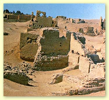

City of Karanis
Located on the Cairo-Fayoum desert at a distance of 33 kilometers from the Fayoum, 109 kilometers from Cairo, the city dates back to the third century BC. And continued in the fifth century and the Coptic era and the dawn of the Islamic era, and includes the remains of two temples were dedicated to the worship of the god Sobek (crocodile), the God of the region, also includes a Roman bath and a group of houses, and there are graves on the opposite side of the city.


The effects of Philadelphia
Established in the third century BC and said in Greek papyri as a center of revelation and prophecy of the gods Amon and Isis .. The loss includes the effects of some estates, such as Greek Apollonius, and there are traces of the cities of Fayoum and Theodlvia Aémraa.
Ruins of the city Dimip lions (Sknuvallos)

Located 3 km north of Lake Karun, a town Sknuvallos ancient Greek and the remnants of the Greek Era, was the city start their course of convoys to the south and desert oases .. And the effects of a small temple of stone walls of the box and still the walls of the city as a temple and roads still remain.

Temple Palace Karun (Deonceas)
Located on the southwestern edge of Lake Karun, 50 km from the city of Fayoum is still the temple retains all its details and general form and decorated entrance disk of the sun also adorn the entrances fees outstanding, was founded the city of Deonceas in the third century, and flourished in the Roman era, and the region remains of a fortress Dqlattiyan.
Or Albraijat (Tbtons)

Located 30 km south west of Fayoum near the village of Qasr brave and was on the beach of Lake Morris old (Korah) was the Temple days, the family of 12 and flourished in Alasraleonany include the effects of the temple and the city or Albraijat ROMANIAN excavation had uncovered recently by the remains of her temple ancient.


حقوق الطبع والنشر محفوظة لموقع معالم مصر السياحية. المظهر: سفر. يتم التشغيل بواسطة Blogger.